For years, the future of the Neighborhood Road area has been an important topic in Mastic Beach. Residents, local officials, and community stakeholders have long discussed ways to strengthen the area, improve its appearance, and create a more connected downtown environment.
That effort reached a major milestone in April 2026, when the Town of Brookhaven adopted a new Land Use Plan and comprehensive zoning updates for the Neighborhood Road Revitalization Area.
The newly adopted framework is intended to guide future redevelopment with a mix of residential, commercial, civic, and public uses while helping create a more walkable downtown district that reflects the character of Mastic Beach.
A Long-Term Plan for Neighborhood Road
The planning process began after the dissolution of the former Village of Mastic Beach, when responsibility for the area shifted back to the Town of Brookhaven.
Since then, the Town has worked through a multi-year planning and review process that included evaluation of existing conditions, community planning, environmental review, and the development of updated zoning tools.
The April 2026 adoption of the Land Use Plan and zoning changes represents an important step because it provides a clearer framework for how the Neighborhood Road area could evolve in the years ahead.
The plan works together with the Urban Renewal Plan, the new form-based zoning framework, and the State Environmental Quality Review Act, or SEQRA, process.
Rather than representing completed construction, the plan provides a roadmap for future redevelopment.
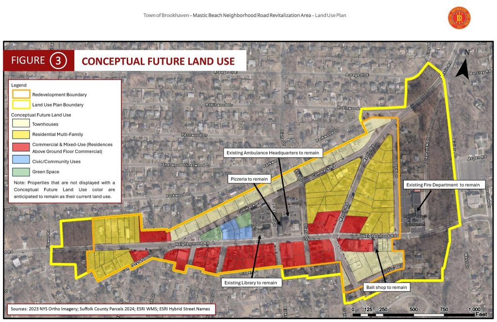
What the Conceptual Land Use Plan Shows
The conceptual future land use map outlines several different types of potential uses throughout the redevelopment area.
These include:
- Townhouses
- Residential multi-family development
- Commercial and mixed-use buildings
- Civic and community uses
- Green space
The plan also identifies several existing community uses that are expected to remain, including the existing fire department, library, ambulance headquarters, pizzeria, and bait shop.
That combination is significant because it shows an effort to build on existing community assets while also creating opportunities for new investment and development.
The goal is not simply to add new buildings. The broader concept is to create a more organized and walkable downtown area where residents can live, shop, access community services, and spend time in public spaces.
A More Walkable Downtown Vision
One of the most notable aspects of the revitalization plan is its focus on creating a more walkable downtown environment.
Neighborhood Road already serves as an important local corridor through Mastic Beach. The new zoning and land use framework is intended to support a more traditional downtown pattern, with residential, commercial, and civic uses located closer together.
That type of development can help create a stronger sense of place and make the area more convenient for residents.
The plan also emphasizes public spaces and a design character connected to the community’s coastal identity, which could help distinguish Mastic Beach from other commercial areas across Long Island.
What the New Zoning Means
The adoption of the Mastic Beach Downtown Zoning District is another important part of the update.
Zoning determines what types of buildings and uses may be developed in a particular area. By creating a dedicated zoning district for the Neighborhood Road area, the Town now has a framework designed specifically around the revitalization goals for downtown Mastic Beach.
The accompanying SEQRA Findings Statement also marks the completion of an important part of the environmental review process.
Together, these approvals create the planning structure that can guide redevelopment proposals as they move forward.
It is important to remember that zoning approval does not mean every property shown on the conceptual map will immediately change. Future development will still depend on individual projects, property ownership, approvals, financing, and other factors.
Preserving Community Uses While Planning for Growth
One positive feature of the conceptual plan is that several familiar community locations are specifically shown as remaining in place.
The map identifies the existing Mastic Beach Fire Department, library, ambulance headquarters, pizzeria, and bait shop as uses that are expected to remain.
This approach helps balance redevelopment with continuity.
For longtime residents, Neighborhood Road is more than a commercial corridor. It is connected to the history and identity of Mastic Beach. Maintaining important community services and familiar local businesses while encouraging carefully planned new development could help the area grow without losing that local character.
What Happens Next?
The adoption of the land use plan and zoning framework establishes the foundation for future redevelopment, but the transformation of Neighborhood Road will likely happen over time.
Individual projects may come forward as property owners, developers, and the Town work within the new planning framework.
Residents can expect future proposals and developments to provide more detail about specific buildings, businesses, housing, public spaces, and infrastructure improvements.
For now, the April 2026 approvals represent a significant planning milestone and provide a clearer picture of the long-term vision for downtown Mastic Beach.
A Positive Step for the Mastic Beach Community
Neighborhood Road has long been one of the most recognizable corridors in Mastic Beach, and its future has the potential to play an important role in the community’s overall quality of life.
A revitalized downtown with housing, businesses, community services, and inviting public spaces could create new reasons for residents to spend time locally while helping strengthen the identity of the area.
The conceptual land use plan is still a vision for the future, but the adoption of the new zoning and planning framework moves that vision closer to becoming achievable.
As future projects are proposed, residents will have an opportunity to see how this long-term plan translates into real changes along Neighborhood Road.
For people who live in Mastic Beach, Shirley, Mastic, and surrounding Brookhaven communities, this is a local development worth watching.
And for anyone considering making the Mastic Beach area home, staying informed about community improvements like the Neighborhood Road revitalization is one of the best ways to understand how the area continues to grow and evolve.
The article is grounded in the update text and development image you provided, and keeps the tone positive while distinguishing between the adopted planning framework and future construction.